The Sacred Valley
Prehistoric Landscapes and Treasures of the Wylye River

Outside Wiltshire (the home county of Stonehenge, Avebury and a plethora of other prehistoric monuments) not many people have heard of the River Wylye. One of a tangle of meandering chalk streams that converge on the cathedral city of Salisbury, it remains largely invisible for much of its length, has never witnessed any great battles (at least, not any that are remembered) and studiously avoids any well known towns.
Yet in the distant past, the Wylye was clearly a river of some importance, whose name must have been known across wide distances from as far back as the Early Neolithic, 6,000–5,500 years ago, when the wild woods bordering it would first have been cleared for grazing and cultivation.
The name our Celtic forebears used for the river has been lost. Nor do we know what mythological significance may have been attributed to it in the Bronze Age, when a scattering of large burial mounds were constructed on its flanks. The skirmishes waged on the ramparts of its Iron Age hillforts have long been forgotten, along with the identity of the woman whose intricate amber necklace and gold jewellery was entombed on its banks 4,000 years ago.
Enough vestiges of these distant eras survive, however, for us to be able to reconstruct the defining cultural changes that swept across the Wessex chalklands before the arrival of the Claudian legions in AD 43. The ancient monuments of the Wylye, in effect, offer us a cross-section of the region’s rich prehistory – one that I’ve particularly relished piecing together, because the river flows close to my home on the Wiltshire-Somerset border. Discovering and learning about the valley’s monuments has literally transformed the way I construe landscapes I’ve lived with for decades, re-connecting me with their essential power and majesty, and it’s this journey that forms the focus of my newsletter this month.
The Early Neolithic
The oldest monument I know of along the Wylye sits, appropriately enough, above the spot where the river rises, not far from the Stourhead Estate. The ridges enfolding this magical little enclave are significant for being the most westerly extensions of the great chalk downland that dominates much of southern Britain, extending as far north as the Yorkshire Wolds and as far south and east as Kent.
Some time around the start of the fourth millennium BC, Neolithic herder-farmers discovered this sheltered Shangri La, presumably by following the river northwards from the coast to its source, which back then would have been carpeted in primeval forest. These ancient pioneers would have recognized the quality of the alluvial soil lining the valley floor and potential of the uplands for grazing. Before being able to exploit any of the land, however, they first had to clear areas of it using axes made from knapped flint – a stone abundant in the area.
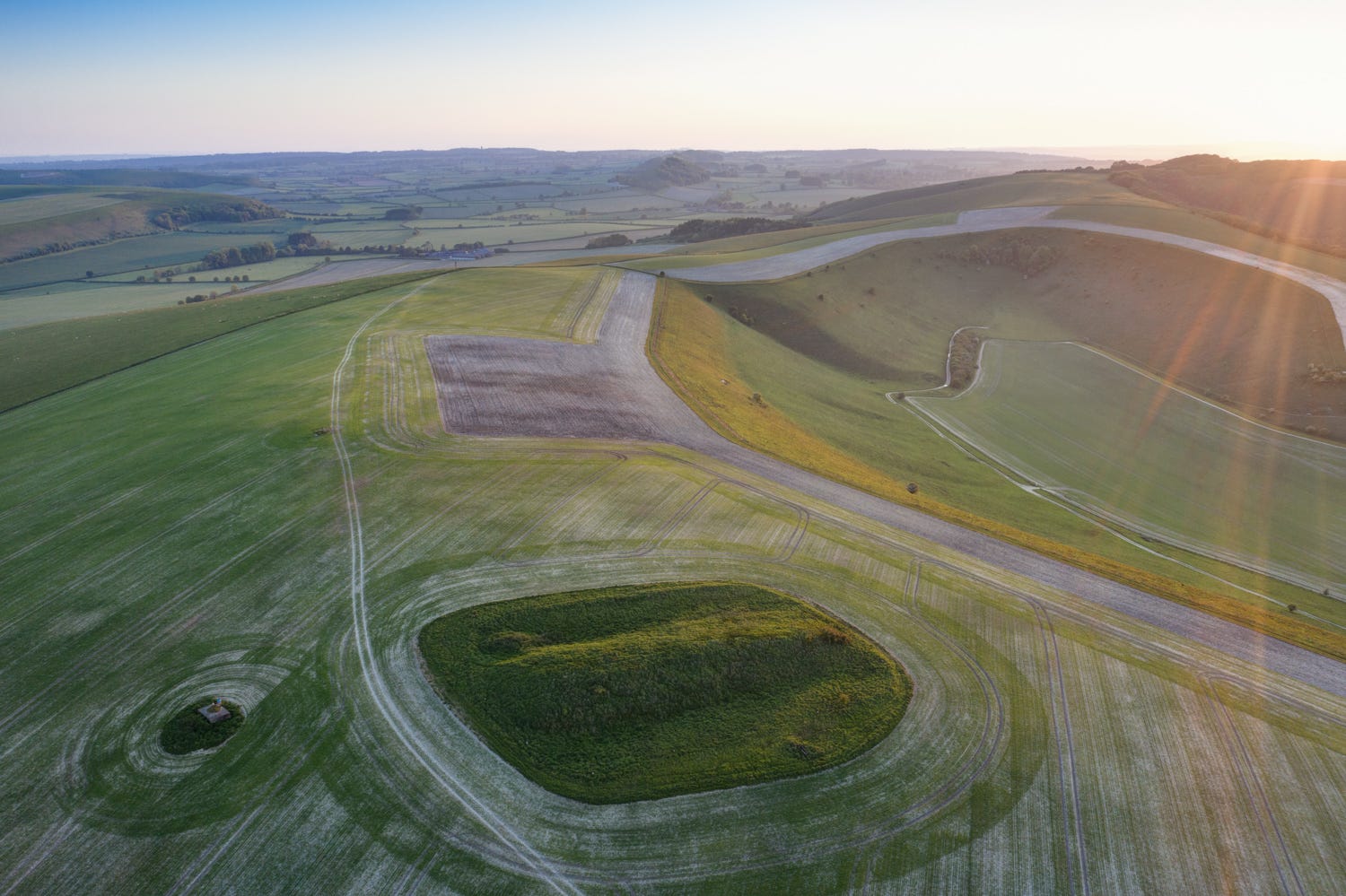
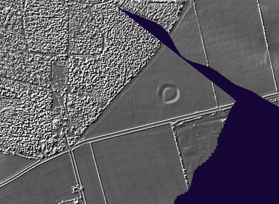
That people came here 6,000 years ago, made camps, cleared woodland, cultivated small plots for wheat and barley and grazed domesticated livestock we know from the wealth of worked flint churned up by ploughing in the area today, and by the presence on White Sheet Hill, near Kilmington, of an enigmatic earthwork known to archaeologists as a ‘Causewayed Enclosure’.
The site was first recorded in the early 19th century by Sir Richard Colt-Hoare, owner of the Stourhead Estate, who excavated a number of Bronze Age barrows near it with his friend and collaborator, William Cunnington, a draper from Warminster, concluding ‘from the slightness of its vallum’ (ie the shallowness of its ditch) the feature must have been ‘of high antiquity’.
What neither men knew back then, however, was that the egg-shaped enclosure originated way back in the 37th century BC – a fact only recently established by radio-carbon dating charred hazlenuts, pig bones and other organic material extracted from the bottom of the ditch (which in its day would have been an impressive 3 metres (10 feet) deep).
Archaeological work, carried out in 1989–1990 ahead of water pipe laying work, also uncovered fragments of Early Neolithic pottery, antler picks and evidence that the enclosure had been recut on several occasions over the century or so during which it was in use.
The precise nature of the rituals that took place here remains a matter of debate, but it seems likely the circle served as a gathering place of some kind. We know from archaeological work carried out over a twenty-year period at a similar site on Hambledon Hill near Blandford that such monuments were often the venue for funerary rites, in which bodies were dismembered and excarnated (de-fleshed), before being left for the birds and elements to cleanse – a kind of Early Neolithic ‘sky burial’ reminiscent of those still conducted by Tibetans.
At Hambledon, and probably here too at White Sheet, the circle, entered via gaps in the ditch known as ‘causeways’, would have been surfaced with a layer of compacted white chalk, making it a prominent feature of the landscape. The ground around would also have been cleared of trees to open up views over the valley.
I’ve photographed the circle on several occasions, in different light and at different times of year, and on one occasion noticed a second enclosure on a spur to the north. Research confirmed this had been identified by archaeologists as another Neolithic monument, but no excavation work has ever been carried out on it. Perhaps one enclosure was used for ceremonies associated with death and the other for marriages and fertility rituals? This Land of the Living/Land of the Ancestors dichotomy would come to fore later in the Neolithic, dominating the wider ceremonial landscapes at sites such as Stonehenge and Avebury.
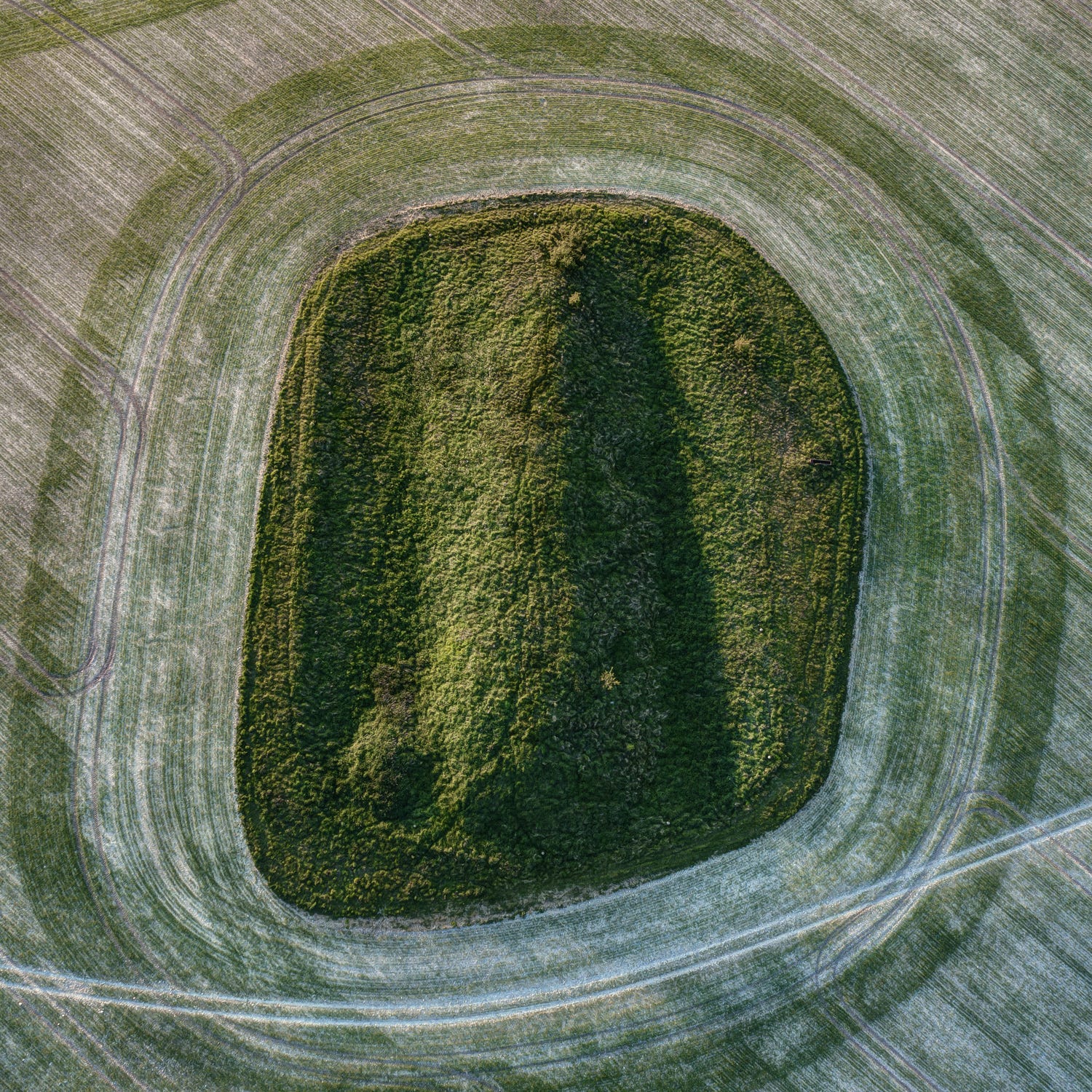
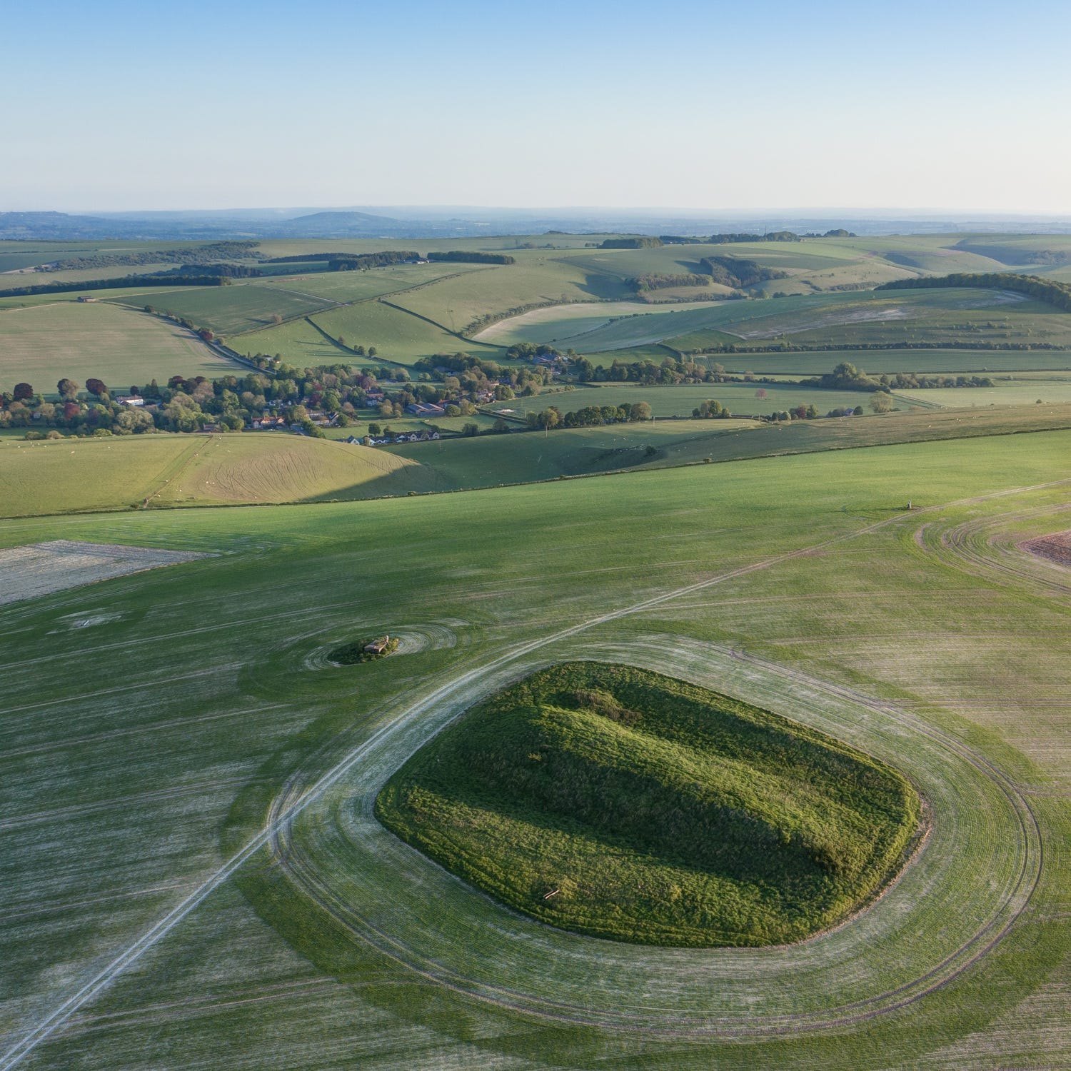
A clue as to what happened to the bones left for the ravens and rain to clean on White Sheet Hill is to be found on the opposite side of the Wylye Valley, on the crest of Cold Kitchen Hill. Here, our Early Neolithic forebears constructed a large chambered tomb, or ‘long barrow’, from chunks of diamond-hard sarsen stone (the same rock used to build the Stonehenge trilithons). The remains of several other tombs may be seen on the hillsides hereabouts; this one, overlooking the village of Kingston Deverill, is by far the largest and best preserved.
It has never been excavated but almost certainly holds a half a dozen stone-lined chambers in which ancestral bones would have been interred, probably in separate compartments for children, young women, older women and men, with elders perhaps in the innermost chamber.
DNA analysis of remains discovered in a barrow of similar proportions in the Cotswolds recently identified 35 individuals, 27 of whom were ‘biological relatives from five continuous generations of an extended family’. The bones were stored in compartments designated according to their line of descent from four women, all of whom had children with the same man. It seems our distant ancestors may have been polygamous . . .
The Middle and Late Neolithic
Towards the middle of the fourth millennium BC, something major happened that would have a big impact on this region’s Neolithic inhabitants. We don’t know precisely what it was, but soil analysis show this period saw a sharp reduction in forest clearance and corresponding increase in woodland regeneration. People appear to have deserted their ancestral lands in the valleys, largely giving up farming and gravitating towards the uplands with their herds of sheep and cattle.
The most likely explanation for this cluster of phenomena is that a cooling of the climate and increased rainfall made farming less dependable. In addition, recent research on Neolithic sites in Central Europe dating from this period have yielded traces of a bacteria believed to be the ancestor of bubonic plague. Could a pandemic have been the cause of what archaeologists nowadays refer to as ‘the Neolithic collapse’? Perhaps the bones interred within the tomb on Cold Kitchen Hill hold some valuable clues?
What is more certain is that the last few centuries of the fourth millennium BC saw a resurgence in population and a sharp rise in forest clearance: people were farming again, in ever greater numbers. They were also congregating at a new kind of earthwork monument on important days in the solar calendar. ‘Henges’ were larger than causewayed enclosures, with wider, deeper ditches and banks on their outside. Over time, these gathering places became bigger and more impressive, and started to acquire megaliths, or standing stones, forming circles aligned with the solstice sunrises and sunsets and with important phases of lunar cycles. Avebury and Stonehenge are the best known examples but there are several others on a comparable scale that have fallen prey to the plough.
In the Wylye Valley, a diminutive henge was excavated on what is now the southeast edge of Southleigh Wood, between the villages of Sutton Veny and Longbridge Deverill. It’s virtually invisible at ground level, but shows up well on Lidar maps. I still haven’t photographed it using a drone but plan to do so in the near future.
By 3,000 BC, the first incarnation of Stonehenge had been carved from the chalklands of Salisbury Plain, a day’s walk to the east, and this must surely have exerted a gravitational influence over the inhabitants of the Wylye Valley, who would have been regular visitors to the great stone circle during the solstice festivals.
At its height around 2,500 BC, the settlement at Durrington Walls, near Stonehenge, was the largest in Europe, with a population of around 3,000–4,000. Livestock fairs would doubtless have been held alongside the big solstice gatherings, in which marriages would have been brokered, disputes settled and ignited, and animals, polished stone axes, furs and other desirable commodities traded.
The Copper and Bronze Ages
It was around 2,500 BC that the great sarsen circle and trilithons were erected at Stonehenge – a monument to which travellers must have come not merely from around southern Britain but far beyond. Analysis of the bones laid to rest in one famous grave at nearby Amesbury have pointed to the Italian Alps as the birthplace of the individual interred within it, whose possessions and style of burial set him apart from those of the local Neolithic people.
Nicknamed for the finely worked arrow heads and stone wrist guard he took with him on his journey to the Afterlife, the ‘Amesbury Archer’ was the harbinger of a wave of migration into southern England from what is now Belgium, the Netherlands and northeast France. These newcomers are generally credited with introducing metal to Britain: the Archer himself, who was buried with gold hair ornaments and a special stone for burnishing copper, is thought to have been a metal worker, which may have explained his high-status burial.

Everything about these new arrivals must have been exotic. Their gleaming daggers and golden jewellery alone would have dazzled their hosts. But the Beaker People, in a remarkably short time, hastened the demise of the old Neolithic way of life. In less than three centuries, the genes of the population who built Stonehenge and Avebury almost disappear from the archaeological record – a dramatic turnover suggesting the wholesale displacement of one people by another (though the revolution does not appear to have been violent).
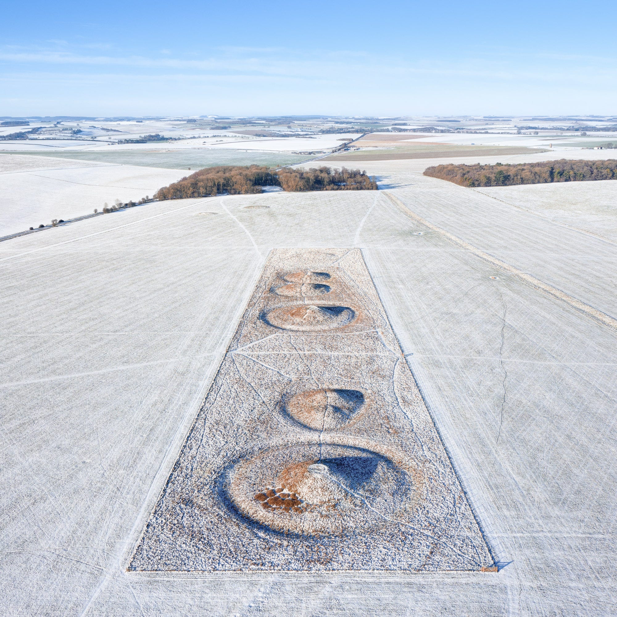
Beyond outward appearances, it seems the ‘Beaker Folk’ followed a way of life not dissimilar to that of the older Neolithic culture, farming, herding and worshipping at the same ceremonial sites. But they did dispose of their dead in a very different way – or at least, their high-status individuals. Both cremated remains and crouched burials were placed under large mounds of earth and turf, along with a handful of treasured personal possessions. In Wessex, many of these were capped with a layer of crushed chalk, making them stand out in the landscape.
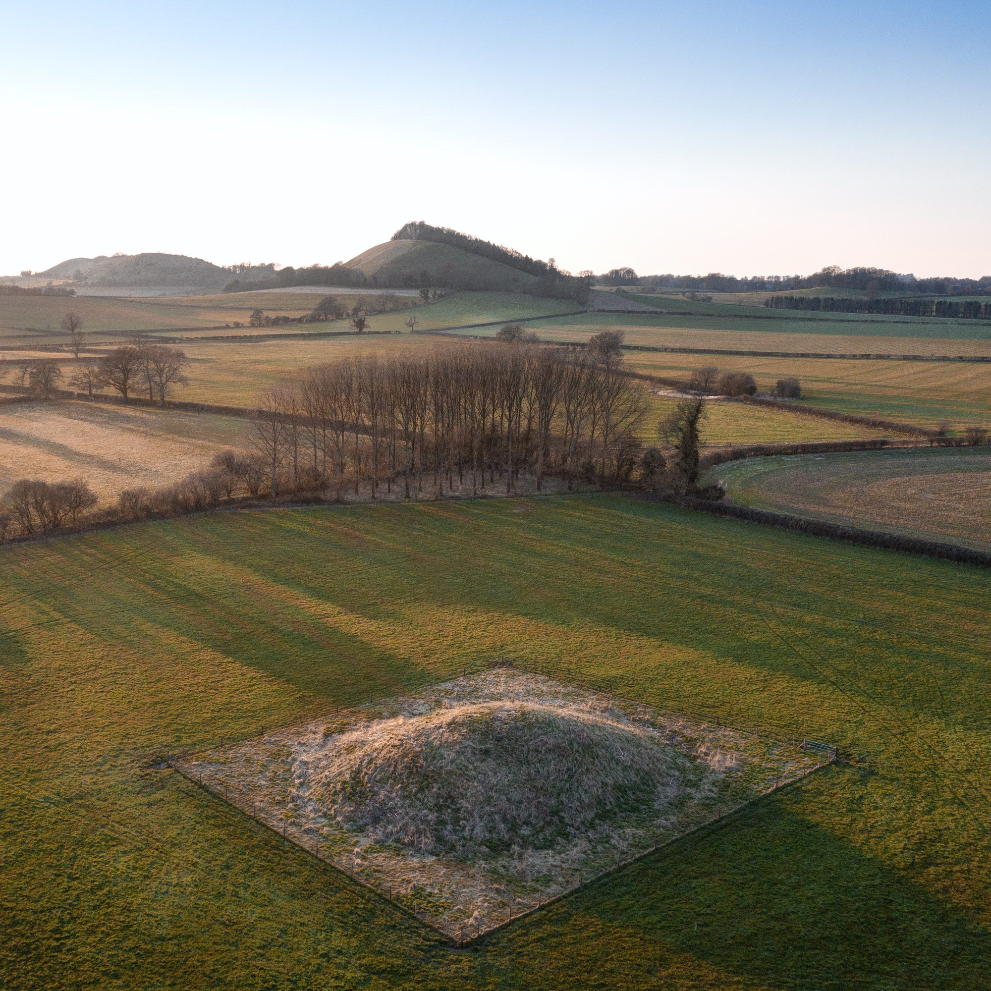
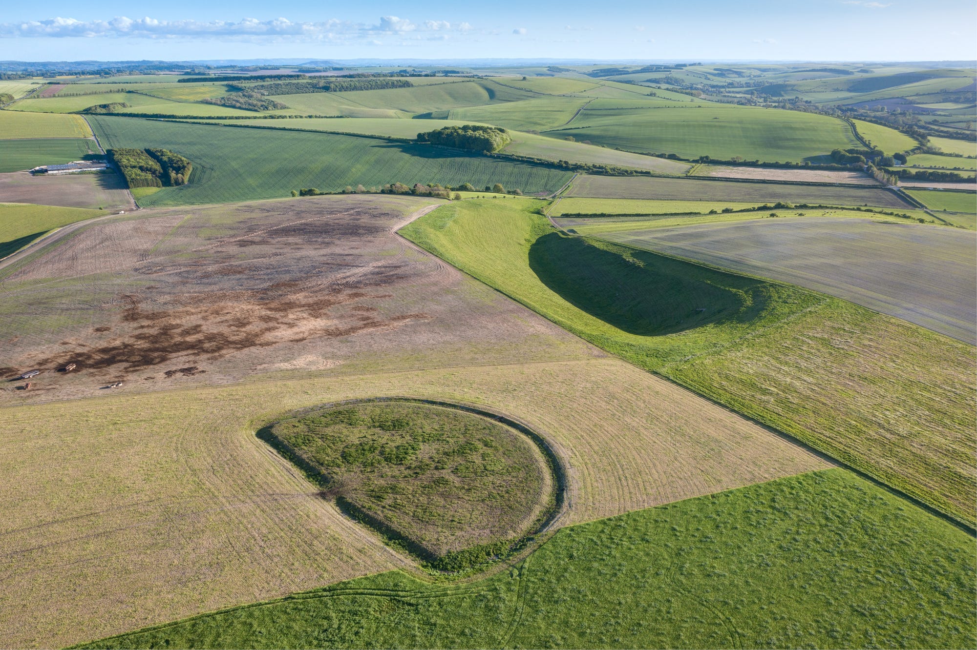
Dozens of these so-called ‘barrows’ litter the flanks of the Wylye Valley. There must originally have been hundreds more at one time but the plough has levelled the majority. A particularly interesting cluster occurs at the head of the Wylye, on and around White Sheet Hill. These held a particular fascination for Colt-Hoare and Cunnington, who broke into nearly three hundred in the early 19th century, documenting their finds in the impressively detailed ‘History of Ancient Wiltshire’.
I refer to this tome a lot in my explorations of the chalklands, and it has led me to some wonderful sites along the Wylye, not least a pair of mounds on the valley floor, close to the river’s source, placed in an amazingly accurate alignment with the long barrow mentioned earlier on top of Cold Kitchen Hill).
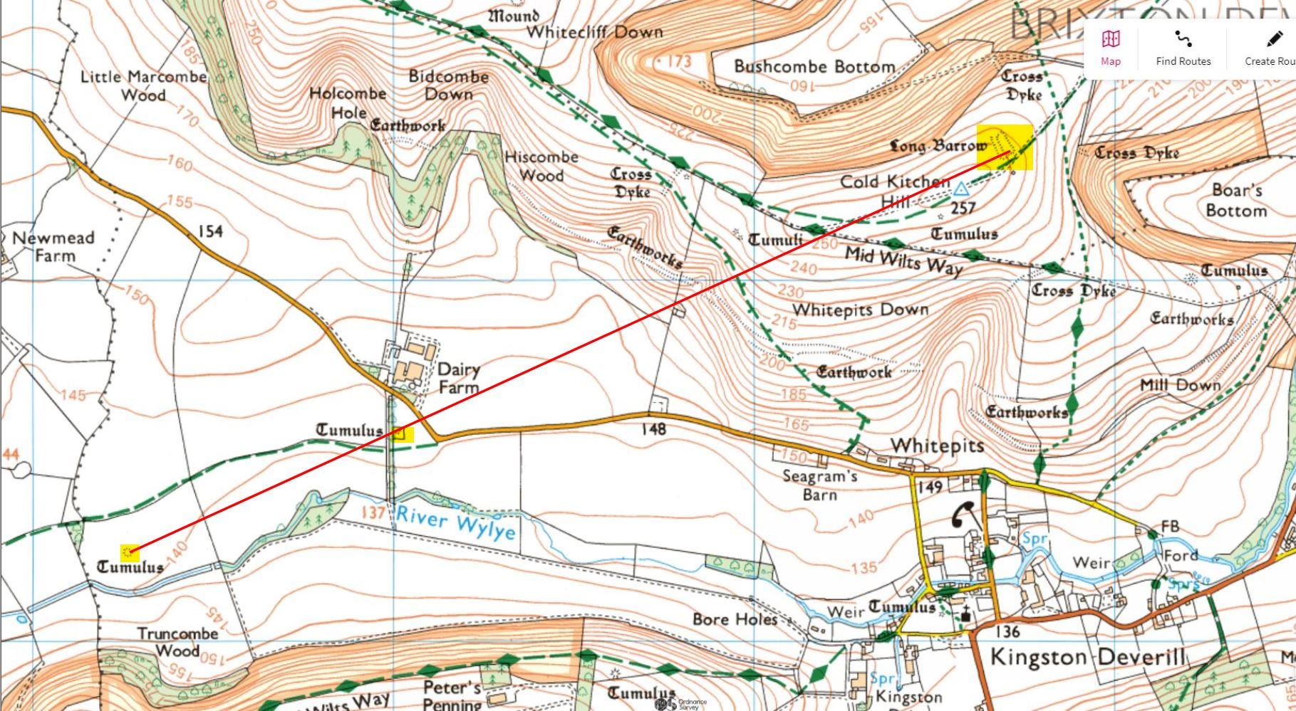
Having been erected on ground that remains waterlogged for much of the year (which tends to turn the ancient contents of barrows to mulch), these two mounds were not deemed worthy of excavation by Messers Colt-Hoare and Cunnington, but others further down the valley were broken open by the pair and yielded some of the most remarkable finds unearthed in their barrow busting careers.
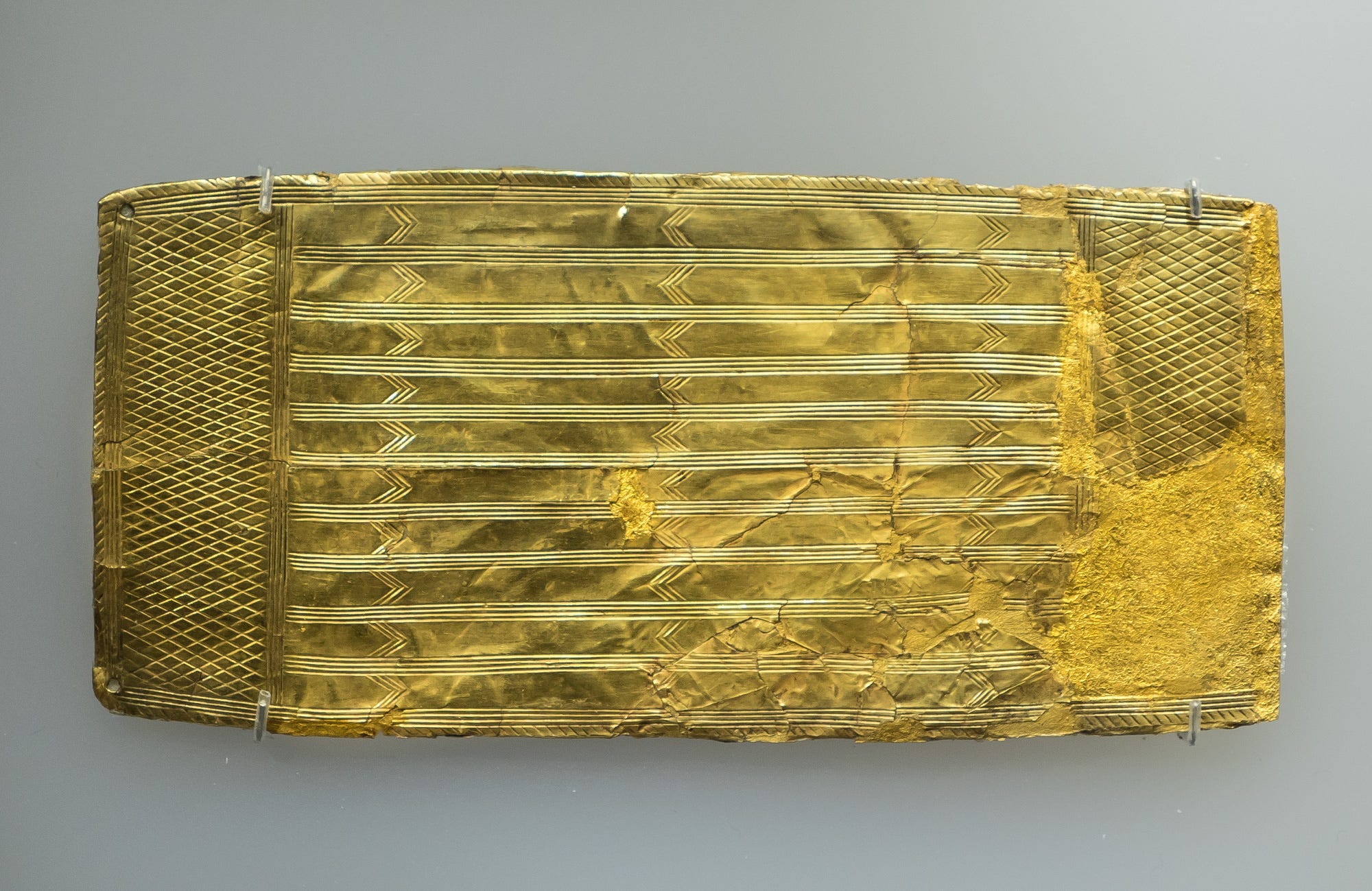
At Upton Lovell, a burial mound dubbed ‘The Golden Barrow’, built beside the river bank (and now sadly ploughed flat), contained an ornate amber spacer-plate necklace and lustrous gold plaque, along with an array of other gold objects.
In another large barrow sited on a hill crest overlooking Upton Lovell, Cunnington unearthed an exquisite necklace comprising 53 beads made of red amber, black shale and blue faience (the latter a rare glass-like material first manufactured in ancient Egypt but which appears, judging by the frequency with which it appears in local Early Bronze Age graves, to have also been made in a workshop somewhere in Wessex).
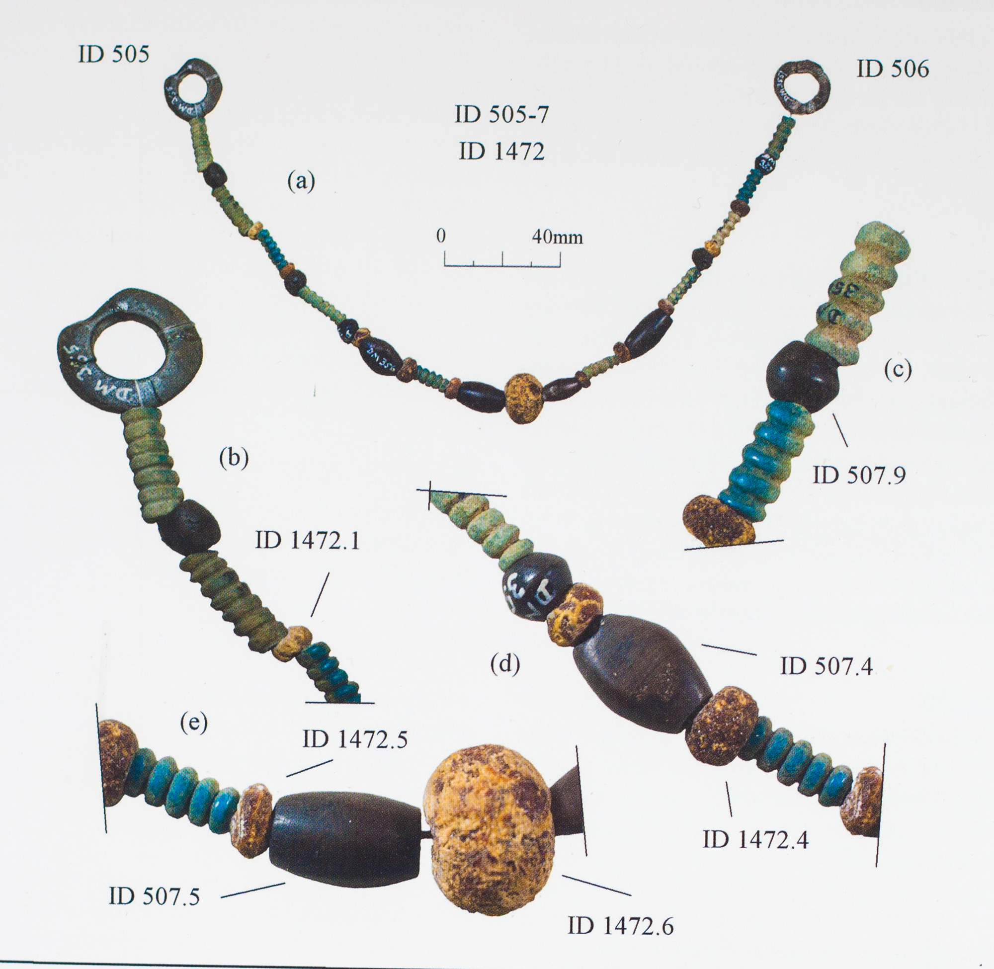
After a lengthy search one wet Sunday afternoon, I found this latter site – labelled on OS maps at ‘The Upton Great Barrow’ – which is now sits in a dense beech coppice, sprouting trees and serving as a pheasant feeding station!).
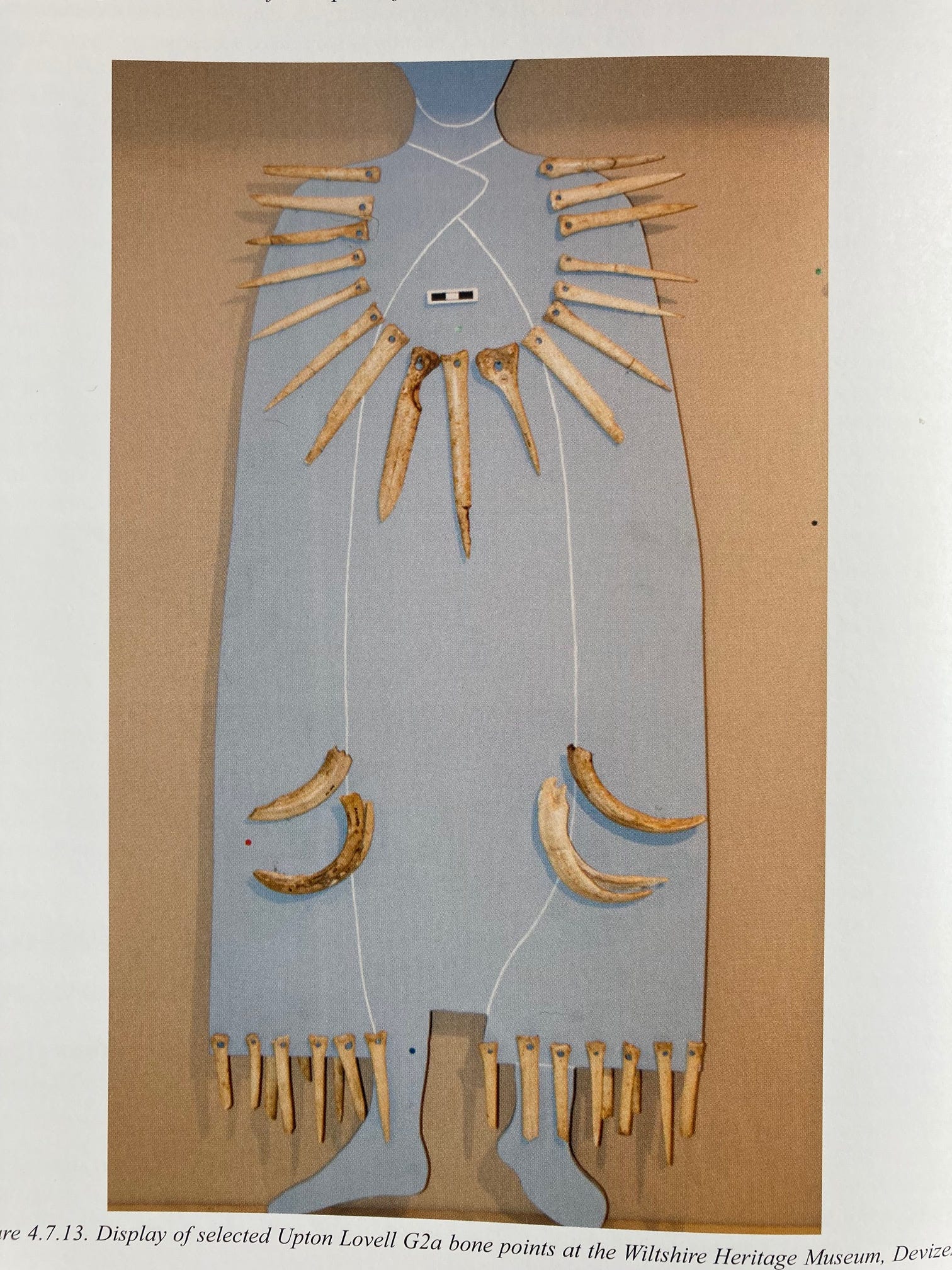
One other Early Bronze Age site in this area deserves a mention for the unusual pierced bone ornaments discovered in it. Though long since ploughed out, this exceptionally rich barrow also held an array of fine, cream coloured stone axe heads and other items of regalia interpreted as belonging to some kind of Shaman. Along with the other treasures unearthed by Colt-Hoare and Cunnington, these wonders now reside in Devizes Museum.
The Late Bronze Age
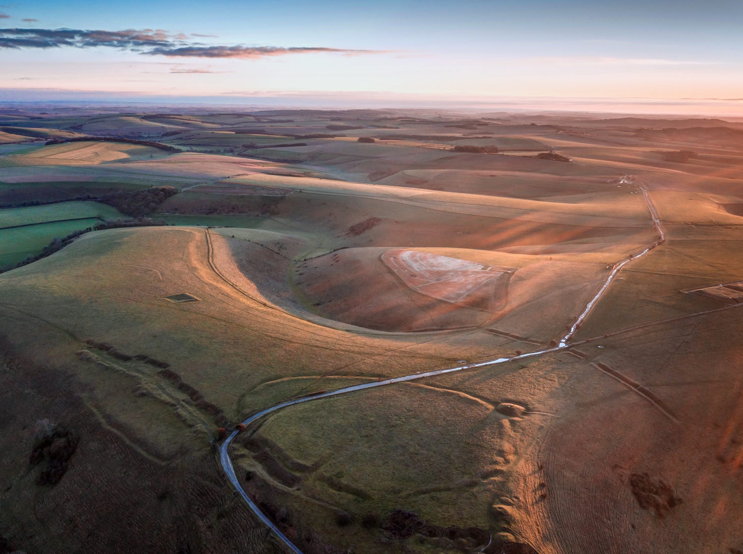
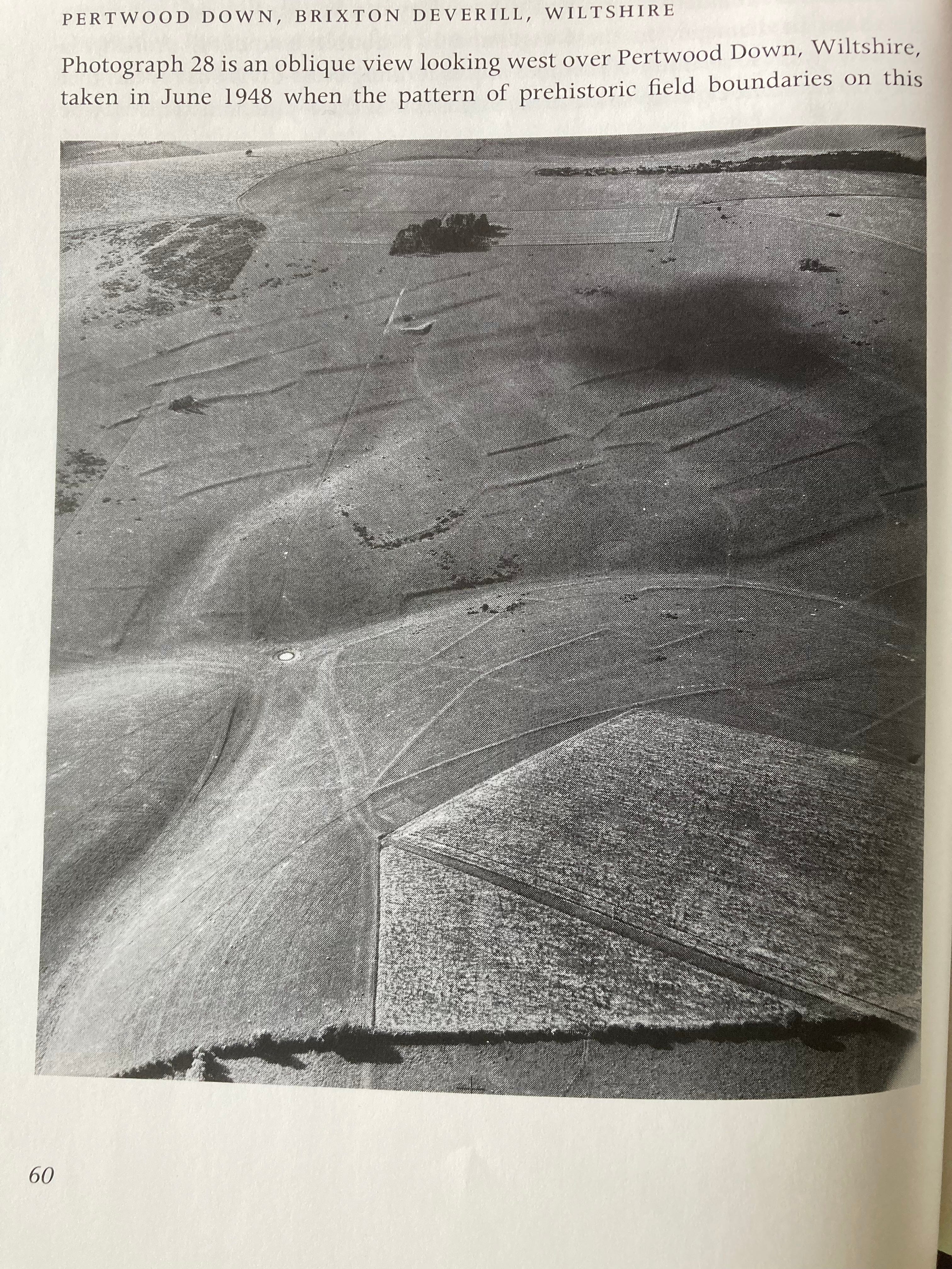
From around 1500 BC, farming intensified on the chalklands. People appear to have started moving around less and living in more permanent settlements, grouped on areas of land that were, for the first time, enclosed by banks and low terraces. The ghostly outlines of these ancient field systems can still be seen in one or two places in the Wylye Valley, notably on the Pertwood Farm, where they were photographed to spectacular effect in the late 1940s.
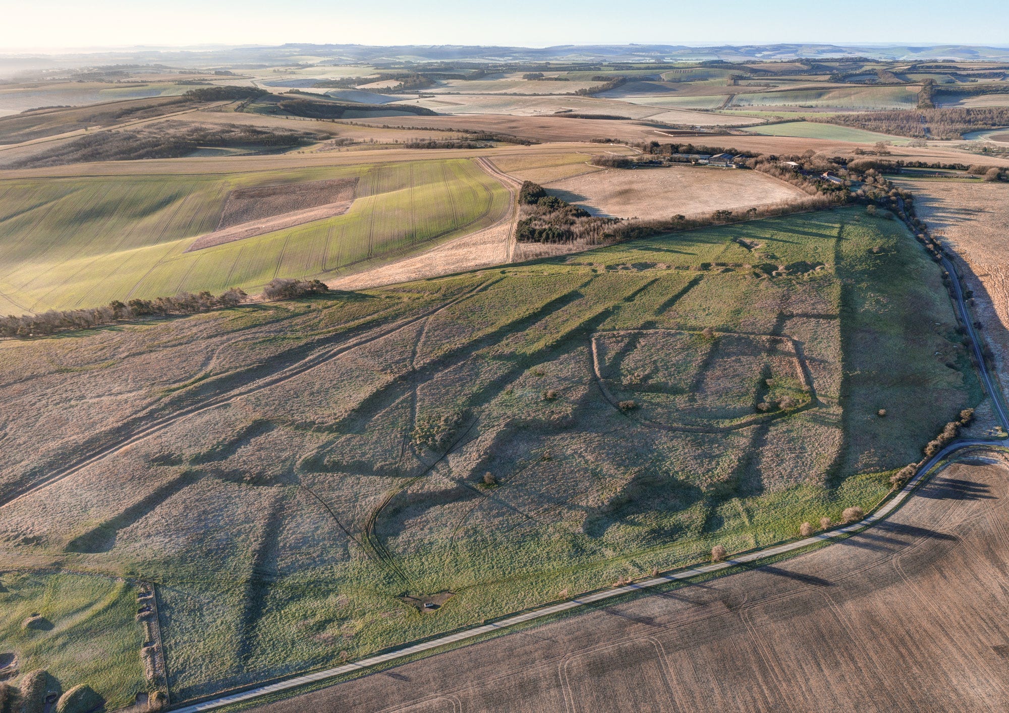
Here's a photograph I took with a drone on the Marlborough Downs near Swindon, showing how the Pertwood terraces might have looked today if they had survived the advent of mechanized ploughing in the 1960s and 1970s.
The enclosure of land and intensification of farming coincides in Britain with the phenomenon of hoarding – the deliberate placement of valuable Bronze items into water or the ground, probably as offerings. Up until this time, status in Bronze Age Wessex tended to be expressed through jewellery and other exotic items such as polished maceheads and richly adorned daggers. But towards the end of the millennia, it appears that élite members of society gained prestige more through the ownership of beautiful bronze swords and war gear, and the custom of hosting feasts. Feasting paraphernalia, such as cauldrons and flesh hooks, often crops up in hoards discovered by archaeologists and metal detectorists. Some have interpreted this as evidence for the rise of a warrior or chiefly class.
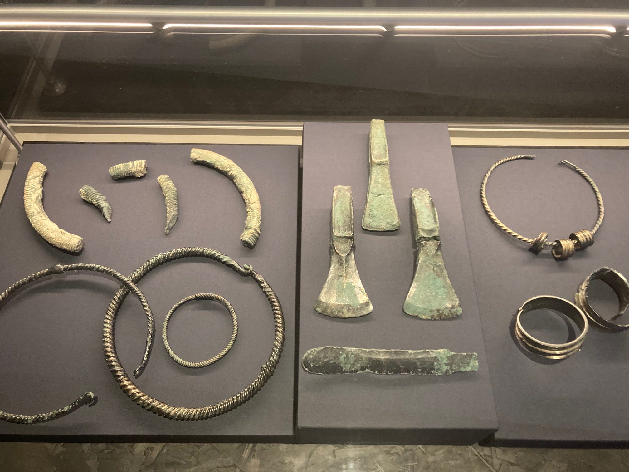
One of the most famous Wessex hoards, comprising a wonderful collection jewellery, ornaments and tools, was found in 2012 near the village of Wylye. Its highlights are currently on show at the World of Stonehenge exhibition in the British Museum (along with the Shaman’s grave goods featured above).
The Early Iron Age
Whereas copper and bronze took a long time to arrive in Britain, but were adopted quickly once they did appear, the advent of iron was a slow-burning revolution that took a few centuries to gather momentum. During the Early Iron Age, from the 8th century BC, people on the Wessex chalklands lived essentially as they had done in the Late Bronze Age, mostly inhabiting farmsteads set amid systems of fields and trackways.
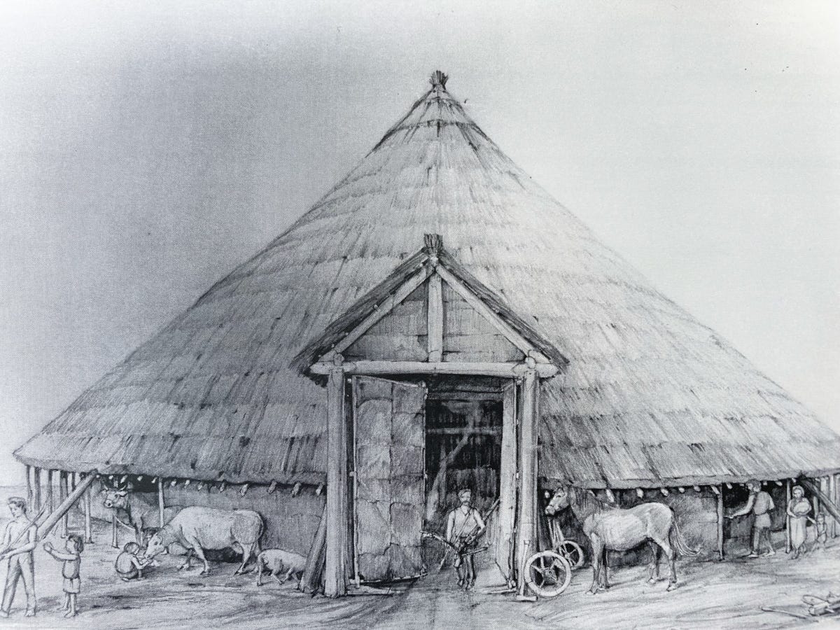
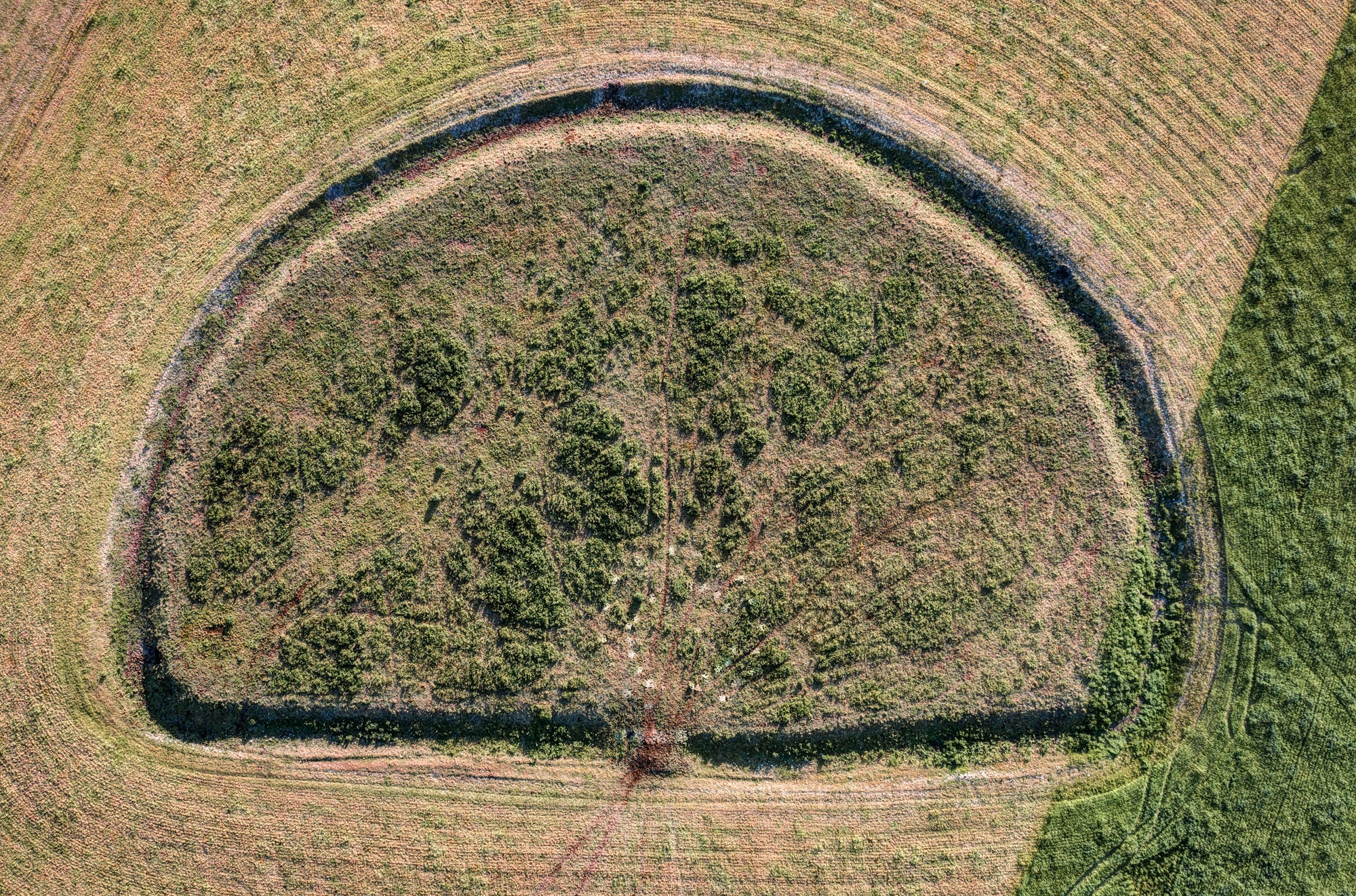
A prime example sits on a hilltop above the village of Longbridge Deverill on Cow Down. The ancient settlement was the subject of an archaeological dig in the late 1950s whose principal discovery, aside from some fine examples of Early Iron Age pottery, was that the site had held four substantial roundhouses, measuring approximately 15 metres in diameter. These appear to have been burned to the ground in what was interpreted as some kind of ‘de-commissioning ritual’, perhaps to mark the death of the chief whose ancestral seat this was.
Here's a delightful reconstructive drawing of the main dwelling, followed by a top-down shot of the site in which I have highlighted the postholes of the roundhouse (now buried under a foot of cley and flint).
Middle and Late Iron Age
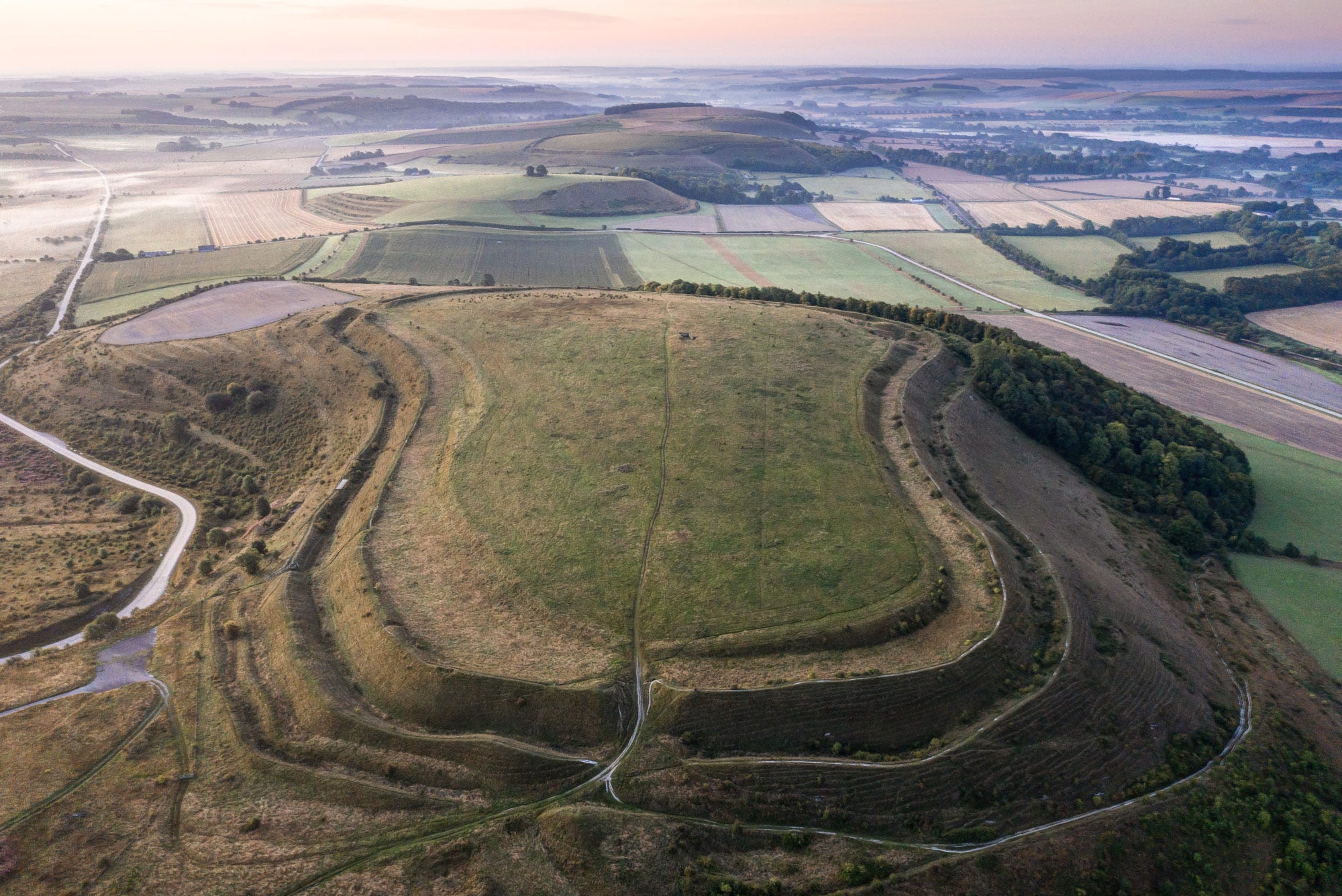
Iron Age Society on the chalklands experienced a period of dramatic change midway through the first millennium BC. Hillforts began to appear in the landscape, reflecting the political instability that must have prevailed at this time.
From around 300 BC, these forts begin to acquire seriously impressive defensives in the form of concentric palisaded ramparts, strengthened with hefty wooden fences and stone revetments. Two particularly large examples survive on the downs outside Warminster – Battlesbury and Scratchbury Camps – which nowadays form part of the army firing range but are freely accessible on foot.
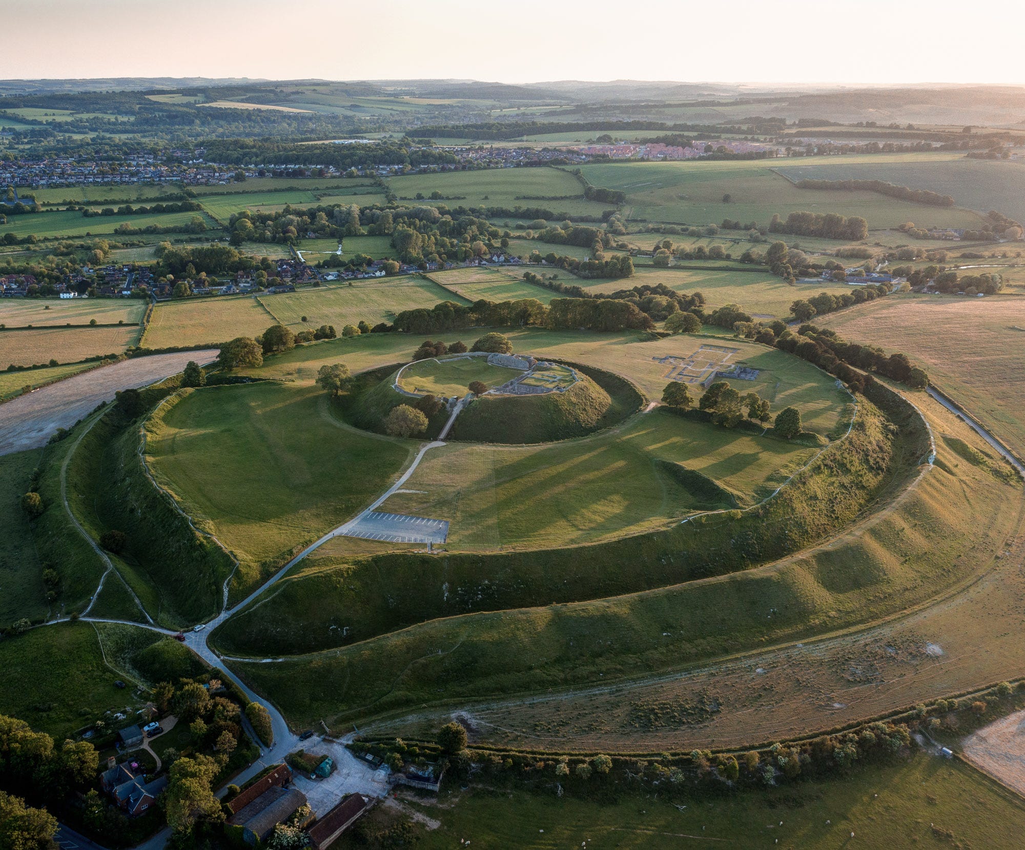
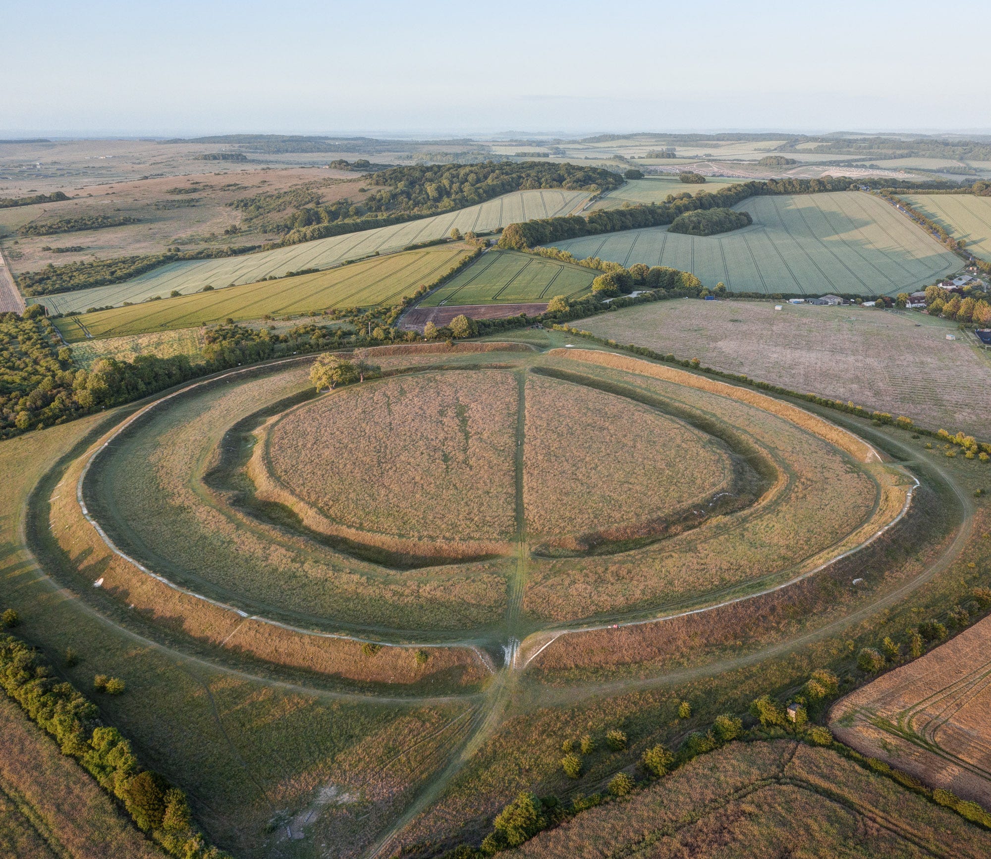
Further down the Wylye Valley, the form of Late Iron Age hillforts changes, becoming noticeably more circular in outline. Here are the two examples: Old Sarum, which after the Norman invasion became William the Conqueror’s regional capital; and Figsbury Ring, whose inner enclosure may have originally been a Neolithic causewayed enclosure. Perhaps their round forms suggest these citadels were created by different tribes?
Like most of the great hillforts of southern Britain, these two appear to have been attacked and deserted in the century leading up to the arrival of the Romans. By this time, the focus of life had shifted more to the rivers, reflecting the rise in importance of trade. Flowing into the Wiltshire Avon at Old Sarum, the Wylye formed part of the major artery connecting the chalklands with the region’s main port at Hengitsbury Head in Christchurch Harbour. It was via this waterway that lead from the Mendip mines was transferred to the sea, and goods imported from the continent – including pottery, wine and other Roman luxuries – made their way to the settlements inland.

Book Update: Pre-Orders Now Open!
The big news this month is that those of you who have not yet pre-ordered my book via last summer’s Crowdfunder campaign are now able to do so through my website! All books purchased directly through me will be signed and embossed with my barrow logo. Best of all, you’ll have the satisfaction of knowing that instead of earning a pittance from the sale in royalties, I’ll be receiving the retailer’s share too, which will really help me continue with this work and hopefully do another book over the coming years.
Here's a link to the pre-order page. The first copies will arrive in early September and you’ll be guaranteed to be among the first to receive one:
Thanks!
Thank you for reading to the end of this Newsletter. I hope you enjoyed my whistlestop tour of the Wylye Valley’s prehistory hotspots and that you’ll be inspired to check some of them out next time you’re in the area, which makes a perfect base from which to visit Stonehenge and its associated monuments.
A belated Happy Beltane to you all!
David
Wonderful photography and insights! Thank you, David!